

We want to make the exchange of field data easier and improve the accessibility of field-level data beyond the farm gate, strengthening cross-supply chain connectivity.
Our core objective is to create impactful change, improve transparency in the food industry, and support the application of regenerative agriculture practices. Our goal is to bring together leaders from across the agri-food industry to work together as we try to transition to a more sustainable, resilient, and transparent food system.
This all said these aims are only the beginning of our journey. Understanding the destination is easy, getting there is the hard part. When understanding how we can achieve these goals, it’s easy to get lost in the complexities and technology involved.
This FAQ series will explain in detail the Global FieldID™ product, answering the most common questions that our team received about our service.
What is the difference between a field and a boundary?
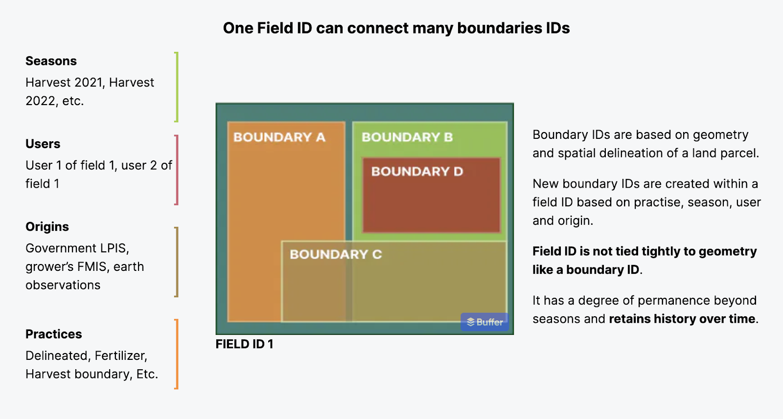
There are a few main differences between a field and a boundary. A field is a conceptual object, which has a defined location, but isn’t tied to a specific geometry. The shape of the field can change over time and still be the same field with the same ID. It has a degree of permanence beyond seasons and retains history over time. Therefore, it is more stable than a boundary and is appropriate for use cases that don't involve complex spatial processing, focusing instead on simply aligning related data, like grouping data related to the same field in a traceability solution.
In contrast, a boundary is a spatial concept. It is based on geometry and spatial delineation of a land parcel. In other words, it uses shapes and lines to show where one piece of land ends and another begins. Boundaries are used most in precision agriculture. They refer to an area of land specific to an operation, even if it only covers part of a field.
In Global FieldID™ , new boundaries are created within a Field based on types, seasons, users, and sources.
What is the relationship between fields and boundaries?
We have a one-to-many relationship between fields and boundaries. This means that each field can connect to many boundaries. Each field always has one active boundary, defining its spatial footprint at a time, which must not overlap with the active boundary of another field.
Aside from the special boundaries that define a field's location, there can also be other boundaries associated with the field that may not define it per se, but need their own identifier. Global FieldID™ allows any number of boundaries to be registered, and thus any points on the map might have multiple boundaries representing specific operations. The boundary of a field can change over time but the history is retained using a link between the field and boundary, each of which has a timestamp.
Any ‘old’ boundary is retained, which helps application developers to maintain an up-to-date view as boundaries change.
Boundary IDs are based on the geometry and spatial delineation of a land parcel. New boundary IDs are created within a field ID based on practice, season, user and origin.
How does Global FieldID™ keep track of changes to fields over time?
Global FieldID™ deals with changes over time in a unique way. It separates the idea of a "field" from its actual physical limits and remembers the past changes. When things change, they can fall into two categories:
Changes to the boundary that don’t turn it into a different field
-
The old boundary ID is ‘deactivated’ (not deleted) and a new boundary is linked in its place, with the date of the change recorded. The field ID doesn’t change.
-
Since the old boundary still exists with its own ID, use cases that depend on identifying a specific boundary are not impacted, but are able to understand that the field itself has since changed.
Changes to the boundary that turn it into a different field (e.g., splits, merges, and farmland, development)
-
It is possible to ‘deactivate’ one or more field IDs and replace them with new fields, each of which has its own boundary (e.g., when a tree line is removed to create a larger single crop area, one new field ID can be created to replace the previous two).
-
All applications integrating Global FieldID™ will be able to trace these events and access the history.
What is the relationship between fields and crop zone polygons?
A crop zone is identified as a boundary within Global FieldID™. A boundary ID can be used to identify a specific area of land within the field because Global FieldID™ also allows the registration of multiple boundaries.
Does Global FieldID™ support all kinds of different field shapes?
Yes, it does. Alongside the primary boundary used to define the location of a field, there can be other types of boundaries, each used for a specific purpose. Even if there is a region within the field, spanning multiple fields or a region that is not part of any field, it can be identified with a boundary ID. We will soon introduce the ability for API client applications to register such boundaries on behalf of their users.
What is the format of a FieldID?
There are two main types of identifiers in Global FieldID™ :
-
The Global FieldID™, is designed to be reliably communicated in both digital and non-digital channels. It is a short sequence of characters, like this: 15KW.V5JZ
-
The Global Boundary ID is designed for software data exchange, and is a UUID, like this: 2bbc9443-7b65-4a9c-806b-78d20298ab4b
Further technical information is available on our Developer Portal.
Does Global FieldID™ plan to serve smallholder farmers outside Europe?
The Global FieldID™ product aims to have a complete set of boundaries for each country it covers. In Europe, Global FieldID™ is live in the UK, France, the Netherlands, Germany, Belgium, Poland, Italy and Spain. In 2023, we have also expanded it to include the US and Brazil. For 2023, we expect to map regions of Argentina and also add smallholder geographies in Asia and Africa.
However, although we will continue to pre-load fields for whole countries ourselves, it is important to understand that Global FieldID works everywhere: users of GFID are able to create field IDs by submitting boundaries, via both our API and user interface. This means that growers anywhere in the world are able to get a FieldID for their fields. Once crowdsourced in this way, the ID and its boundary becomes available to all FieldID users.
Bottom line
Through our innovative Global FieldID™, we're simplifying how field data is managed and shared, making it more accessible and useful for all stakeholders involved.
By acknowledging the difference between fields and boundaries and the often complex layers of boundaries, we've developed a system that keeps a detailed record of changes over time, ensuring data accuracy and transparency. This approach not only supports precision agriculture but also encourages practices that contribute to a more sustainable and resilient food system.


